Doughgob Camp
This weekend Lynae and I spent a night at Doughgob Camp on Forest Road 41 in the GPNF. It's an unimproved site on the side of a ridge, surrounded by huckleberry bushes. This was the first time I have camped there, but it has been a place of formative experiences for me in the past. And this time was no different, because I wanted to drive the length of road 41.
 According to the Forest Service's latest update, " From Lookout Mountain to Sunset Falls the road [41] is rough and slow going. High clearance vehicle recommended." That was posted this Spring, but locals know it has been true for the past fifteen years at least. This road is known for its potholes, waterblocks and ruts. And the only vehicle I had to drive on it was my Kia Rio. I had some trepidation, but I gave us extra time in case we got stranded, and I prepared my car. So after I got off work on Friday we ate dinner, packed the rest of our gear, and left.
We left before 7 PM because I wanted to arrive before sunset at 8:45. The road was as terrible as usual but I was able to crawl along in first gear at about 8 mph all the way up to Bluff Mountain trailhead. Which is a beautiful place. It's on the ridge looking West across the Copper Creek valley to Silver Star Mountain and to the East across the Washougal River valley to Mt. Hood and Mt. Jefferson. This is the area where I saw my first bear. We took a quick look before continuing. There we encountered the first feature that I thought might be impassable; a deep hole on the downhill side of the road. Fortunately there was room on the uphill side to get around it.
Doughgob itself is easy to miss. It is a sheltered grassy spot with a rock fire pit and the busted remains of a picnic table. The nearest water is a quarter mile down the gravel road which turns off just east of the camp site. You could pitch two tents, but after that you would probably run out of flat ground. We arrived around 8:40, set up the tent and got a fire going. Over the fire we roasted doughbobs, which is just biscuit dough roasted on the fat end of a stick. The night passed peacefully
On Saturday morning I made bacon and pancakes for breakfast. Then we spent some time picking up trash in the site and took a walk down the adjacent road. By ten we had packed everything up, said a quick prayer, and we started to drive East on road 41. The road was the same quality as it had been. We followed the US Topo map for Lookout Mountain and found it to be accurate.
The junction with Forest Road 43 is two miles East of Spring Camp. That is where we left Road 41 to head down to Hemlock and Carson. Road 43 is in much better condition. We finished out our adventure by visiting the Gorge Interpretive Center in Stevenson on our way home. In all, it was an enjoyable and rewarding trip.
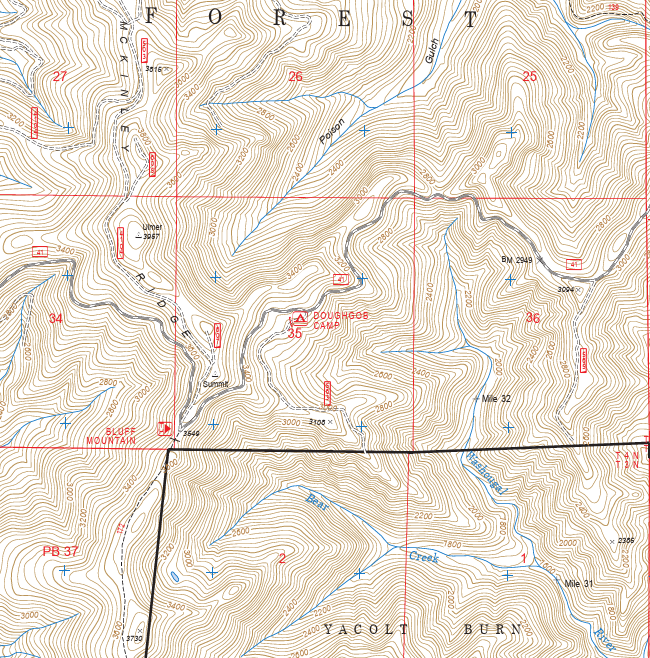
We left before 7 PM because I wanted to arrive before sunset at 8:45. The road was as terrible as usual but I was able to crawl along in first gear at about 8 mph all the way up to Bluff Mountain trailhead. Which is a beautiful place. It's on the ridge looking West across the Copper Creek valley to Silver Star Mountain and to the East across the Washougal River valley to Mt. Hood and Mt. Jefferson. This is the area where I saw my first bear. We took a quick look before continuing. There we encountered the first feature that I thought might be impassable; a deep hole on the downhill side of the road. Fortunately there was room on the uphill side to get around it.
Doughgob itself is easy to miss. It is a sheltered grassy spot with a rock fire pit and the busted remains of a picnic table. The nearest water is a quarter mile down the gravel road which turns off just east of the camp site. You could pitch two tents, but after that you would probably run out of flat ground. We arrived around 8:40, set up the tent and got a fire going. Over the fire we roasted doughbobs, which is just biscuit dough roasted on the fat end of a stick. The night passed peacefully
On Saturday morning I made bacon and pancakes for breakfast. Then we spent some time picking up trash in the site and took a walk down the adjacent road. By ten we had packed everything up, said a quick prayer, and we started to drive East on road 41. The road was the same quality as it had been. We followed the US Topo map for Lookout Mountain and found it to be accurate.
Fourth of July and Spring Camps
There are two more unimproved camps on the ridge along road 41; Fourth of July camp and Springs Camp. Fourth of July Camp is located on a shoulder of Lookout Mountain and has room for a number of campers. It looks out over the East Fork of the Lewis River. There is even a developed spring. Just follow a trail to the West and listen for the sound of falling water. It will lead you down to an old metal pipe that supplied water to an old cabin. The wooden foundation and collapsed walls are still there. If I were ever to organize an event to fill in some of Road 41's potholes (I would really like to), I might base it out of 4th of July camp. Spring Camp is another single-site, unimproved camp immediately Northeast of Little Lookout Mountain. It is a little more open to the road than Doughgob. Someone had lashed together a wood table off to the side of the site. Winter snows had partially collapsed it, but we set it back up. If I ever hike Lookout Mountain, I would like to stay at Spring Camp. I would probably drive to it from Forest road 43. |
| At Spring Camp with Little Lookout Mountain behind. |
posted by Jeremy VanGelder @ 6:45 PM
![]()

0 Comments:
Post a Comment
Subscribe to Post Comments [Atom]
<< Home